
Network data validation
An important thing is to test if your data work properly for routing.
If you are more or less fit to UMN MapServer you can easily do some tests.
First of all many thank to Stephen WOODBRIDGE for that idea.
You need to type the following commands on your vertices_tmp-table
alter table vertices_tmp add column cnt integer;
update vertices_tmp set cnt=0;
update vertices_tmp set cnt=cnt+1 from ways where ways.source=vertices_tmp.id;
update vertices_tmp set cnt=cnt+1 from ways where ways.target=vertices_tmp.id;
This will display red dots at dead ends and green dots as good connections be segments.
You can visualize it with the UMN MapServer, just take a mapfile like:
MAP

NAME           'mymap'
STATUS ON
#EXTENT 3427065.200000 5788323.530000 3443999.370000 5800691.660000
#EXTENT 7.9189 52.2102 8.1716 52.3467
EXTENT 880000 6840000 915000 6860000
IMAGECOLOR 255 255 255
SIZE      700 700
SYMBOLSET       '/your_path/symbols/symbols.sym'
FONTSET       '/your_path/fonts/fonts.list'

WEB
TEMPLATE  'template.html'
IMAGEPATH '/your_path/tmp/'
IMAGEURL   '/tmp/'

METADATA
'WMS_TITLE'   'Gastronomap_routing'
 'WMS_FEATURE_INFO_MIME_TYPE' 'text/html'
'WMS_ONLINERESOURCE'   'http://localhost/cgi-bin/mapserv?map=/your_path/routing.map'
        'WMS_SRS'       "EPSG:900913"
  END
END

PROJECTION
'init=epsg:900913'
END

LAYER
OFFSITE 255 255 255
#LABELITEM 'name'
TOLERANCE 20
NAME            'streets'
TYPE            LINE
STATUS  DEFAULT
CONNECTIONTYPE postgis
CONNECTION 'user=postgres password=postgres dbname=routing host=localhost port=5432'
DATA 'the_geom from ways as foo using unique gid using SRID=900913'
CLASSITEM 'gid'
TEMPLATE 'ausgabe.phtml'

METADATA
'WMS_TITLE'   'streets'
'WMS_SRS'    "EPSG:900913"
'WMS_INCLUDE_ITEMS' 'all'
END

CLASS
TEXT ([gid],[source],[target])
EXPRESSION /./

STYLE
WIDTH 1
COLOR 0 0 0
END

LABEL
        TYPE TRUETYPE
        ANTIALIAS TRUE
        FONT 'arial'
        COLOR 0 0 0
        BACKGROUNDCOLOR 240 240 240
         POSITION cc
          MINSIZE 8
        MAXSIZE 12
        BUFFER 2
         END
END
END

LAYER
OFFSITE 255 255 255
#LABELITEM 'name'
TOLERANCE 20
NAME            'dead_ends'
TYPE            POINT
STATUS  DEFAULT
CONNECTIONTYPE postgis
CONNECTION 'user=postgres password=postgres dbname=routing host=localhost port=5432'
DATA 'the_geom from vertices_tmp as foo using unique id using SRID=900913'


CLASSITEM 'cnt'
TEMPLATE 'ausgabe.phtml'

METADATA
'WMS_TITLE'   'dead_ends'
'WMS_SRS'    "EPSG:900913"
'WMS_INCLUDE_ITEMS' 'all'
END
CLASS
Text ([id])
EXPRESSION /1/
STYLE
SYMBOL 'tent'
SIZE 11
COLOR 255 0 0
END

LABEL
        TYPE TRUETYPE
        ANTIALIAS TRUE
        FONT 'arial'
        COLOR 255 0 0
        BACKGROUNDCOLOR 240 240 240
         POSITION cr
          MINSIZE 8
        MAXSIZE 12
        BUFFER 2
         END
END

CLASS
TEXT ([id])
EXPRESSION /./

STYLE
SYMBOL 'tent'
SIZE 11
COLOR 0 0 255
END

LABEL
        TYPE TRUETYPE
        ANTIALIAS TRUE
        FONT 'arial'
        COLOR 0 0 255
        BACKGROUNDCOLOR 240 240 240
         POSITION cr
          MINSIZE 8
        MAXSIZE 12
        BUFFER 2
         END
END
END
END
If you open your MapServer-testing-apllication via: http://localhost/cgi-bin/mapserv?map=/var/www/gastronomap_wms/gastronomap_routing.map
and you zoom in you get something like:
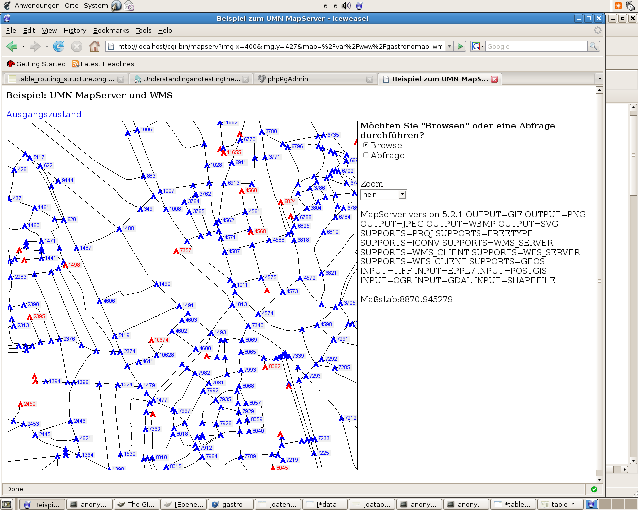
Everything fine with the data ! :-)
But if it looks like:
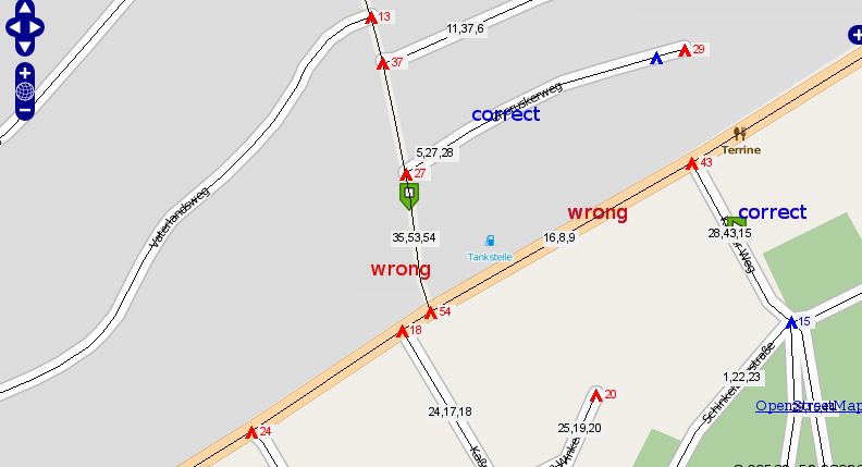
Definetely something went wrong……..